

Maps & Guides
Connecticut River Conservancy offers a variety of recreation and paddling maps of the Connecticut River. To place an order please visit our online store.


The Connecticut River Paddlers' Trail maps (top 2 on the left) are $11.95, and the other Recreational Guides above are $7.95 for regular maps or $17 for laminated maps.

Connecticut River Paddler's Trail Interactive Map
Download our app to access the 410-mile long Connecticut River Paddlers’ Trail! Mostly meandering, but at times rushing forcefully, the Connecticut River flows past a diverse landscape of rich agricultural lands, rural communities, urban centers, and tidal marshes.
Navigational Maps & Guides
The Connecticut River Paddlers’ Trail for launch points and campsites in NH, VT, MA & CT
Boating in Upper Valley: maps, portages and other good information (CT River Joint Commissions)
The Northern Forest Canoe Trail linking NY, VT, NH, Maine, and Québec.
Camping, canoeing, and kayaking in Turners Falls and Northfield, MA (First Light Power Resources)
Places to Visit in Pioneer Valley by Boat on the Connecticut River (Holyoke Gas & Electric)
Water Trails in Connecticut (Rivers Alliance of CT)
Public use areas and access points in central Massachusetts (Holyoke Gas & Electric)
Millers River Blue Trail in northern Massachusettes (Millers River Watershed Council)
River Safety & Flow Information
Boating Safety Guidelines from the Center for Disease Control
Flood predictions and times of cresting
Water release information from dams on Connecticut and Deerfield Rivers
Detailed River Maps
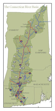

Connecticut River Sub-Watersheds
This map of the Connecticut River watershed outlines the entire area that drains, including the portion in Canada. It also shows major tributaries with outlines of their sub-watersheds. Municipal boundaries within the river basin.
This map was prepared by the US Fish and Wildlife Service.